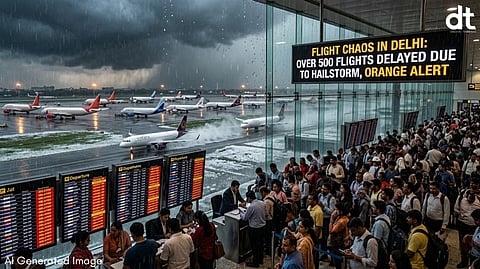
Travelers at Indira Gandhi International (IGI) Airport faced a day of unprecedented turbulence on Tuesday as a volatile mix of localized extreme weather and international conflict converged to cripple flight schedules. Over 500 flights were caught in a logjam of delays, while several others were forced to divert or cancel entirely, leaving thousands of passengers stranded in the terminal.
A Sky Divided: Hail and Dust
The primary catalyst for the domestic disruption was a sudden, intense weather system that swept through the National Capital Region. While much of the city remained relatively dry, the western pockets—specifically Dwarka, Palam, and Najafgarh—were hammered by a localized hailstorm and heavy downpours shortly after noon.
According to data from the India Meteorological Department (IMD), Palam recorded nearly 10mm of rainfall in a concentrated burst, accompanied by winds gusting up to 40 km/h. The severity of the hailstorm near the runways forced air traffic control to divert at least five flights to neighboring airports, as visibility and safety parameters breached operational limits.
Flight tracking platforms reported that nearly every scheduled arrival and departure felt the ripple effect, with average wait times stretching to 30 minutes and beyond. Airport authorities took to social media to urge commuters to verify their flight status before heading to the terminal, citing "short-term disruptions" caused by the atmospheric instability.
Global Echoes: The Middle East Factor
Beyond the local weather, the airport's international wing faced a different kind of storm. Ten flights connecting Delhi to major hubs in West Asia—including Dubai, Abu Dhabi, Kuwait, and Baghdad—were scrapped. These cancellations were not weather-related but were a direct fallout of escalating geopolitical tensions following a drone attack in the Middle East. The resulting closure or restricted use of specific air corridors forced carriers to axe routes, adding another layer of complexity to the day's operations.
Temperature Seesaw: Heatwave on the Horizon
Despite the rain providing a temporary reprieve from the heat, the IMD warns that this "cool" spell is an anomaly. Tuesday’s maximum temperature settled at 33.6°C, which, while lower than peak summer expectations, was actually six degrees above the seasonal normal for a rain-affected day.
"The Western Disturbance currently influencing the region is expected to withdraw by Thursday," noted an IMD official. "Once the skies clear, we are looking at a rapid mercury climb."
Weather Outlook for the Week:
Wednesday: Continued thundery development likely in the evening.
Thursday – Friday: Gradual clearing of the skies; temperatures rising to 37°C.
The Weekend: A potential heatwave surge, with the mercury expected to hit the 40°C mark by Sunday.
While the runways have largely returned to normal operations today, the combined impact of Tuesday’s "perfect storm" serves as a stark reminder of how vulnerable modern air travel remains to both the whims of nature and the volatility of global politics.
𝐒𝐭𝐚𝐲 𝐢𝐧𝐟𝐨𝐫𝐦𝐞𝐝 𝐰𝐢𝐭𝐡 𝐨𝐮𝐫 𝐥𝐚𝐭𝐞𝐬𝐭 𝐮𝐩𝐝𝐚𝐭𝐞𝐬 𝐛𝐲 𝐣𝐨𝐢𝐧𝐢𝐧𝐠 𝐭𝐡𝐞 WhatsApp Channel now! 👈📲
𝑭𝒐𝒍𝒍𝒐𝒘 𝑶𝒖𝒓 𝑺𝒐𝒄𝒊𝒂𝒍 𝑴𝒆𝒅𝒊𝒂 𝑷𝒂𝒈𝒆𝐬 👉 Facebook, LinkedIn, Twitter, Instagram
